
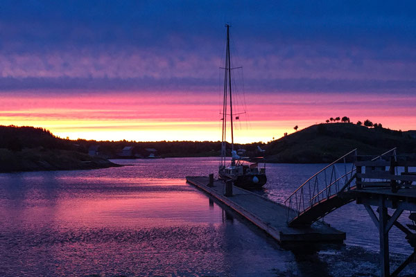
Zum Abschluss der Saison noch ein schöner Segeltag kurz vor unserem Ziel in Brønnøysund.
At the end of the season a beautiful day of sailing, shortly before our final destination for this year in Brønnøysund.
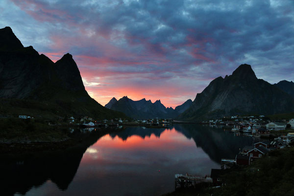
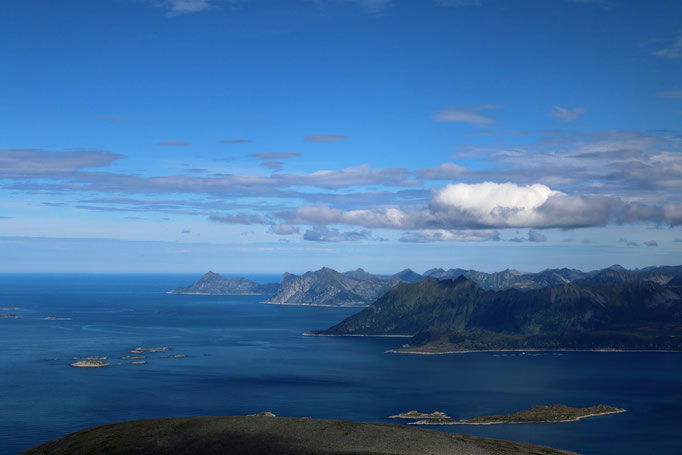
10.10.2016 Sandnessjøen - Brønnøysund


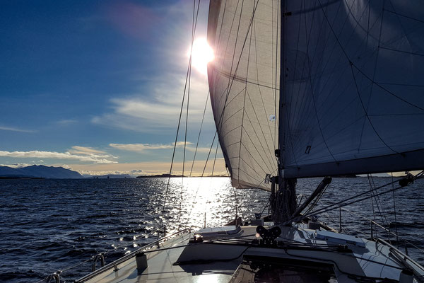


Die letzten Tage fuhren wir über Sandnessjøen, Tjotta und Ylvingen nach Brønnøysund zu unserem Winterlager. Ein stabiles Hochdruckwetter beschert uns herrliche Herbsttage. Durch den schwachen Wind geht das Segeln sehr langsam, doch die Etappen sind kurz und wir genießen die Tage auf dem Meer. Das Boot wird die nächsten Tage aus dem Wasser geholt, gereinigt und an Land gestellt. Im März nächsten Jahres wollen wir wieder los…..bis dann.
During the last days we sailed to Brønnøysund, passing Sandnessjøen, Tjotta and Ylvingen. A high pressure weather system during these days is creating for us a perfect autumn. As the wind is very gentle, we are sailing slow. However, as we are facing only short legs, we enjoy the days a lot. The boat will be taken during the next days with a crane ashore, will be cleaned and stored until our planned start next year in early march…
27.09.2016 Mo i Rana


In den nächsten Tagen planen wir langsam Richtung Brønnøysund zu fahren, wo wir in ca. einer Woche das Boot für den Winter an Land stellen wollen. Über die Orte Sleneset und Nesna fahren wir den langen Rainfjorden nach Mo i Rana. Dort wird das Gas nochmals aufgefüllt. Da die Systeme für die Gasflaschen nicht vereinheitlicht sind – Norwegen hat ein eigenes System – gibt es nur in einigen Orten entlang der Küste für uns die Möglichkeit Gas zu tanken. Ach ja…und der Herbst hat Einzug gehalten…
For the next days we plan to continue sailing towards Bronnoysund, where we plan to store the boat for the winter onshore. Before we sail the Rainfjorden to Mo I Rana, we pass the villages of Sleneset and Nesna. In Mo I Rana we fill our gas bottle. The gas filling systems are not unified - Norway has its own system – there are only a few locations along the coast where we are able to refill. And by the way…. autumn has started…
20.09.2016 Sanna/Træna


Da das Wetter weiterhin stabil bleiben soll, fahren wir nochmals nach Sanna, der äußersten Insel des Træna Archipels. Wir besichtigen dort eine große Höhle, in der Spuren einer 3000 Jahre alten Besiedelung gefunden wurden. Danach umrunden wir die Insel zu Fuß. Es ist einsam und wunderschön.
Today day we sail to Sanna, one of the islands of the Træna Archipels. We are hiking to a huge cave in the south east of the island. In the cave scientists found the proof of early settlement which is dated 3000 years before our time. Afterwards we are hiking clockwise around the island.
16.09.2016 Træna
Zusätzlich zu den Bildern haben wir ein Video gedreht von unserer Fahrt nach Træna. Viel Spass beim Betrachten.
In addition to the pictures, we produced a video from our sailing to Træna. Enjoy the video.


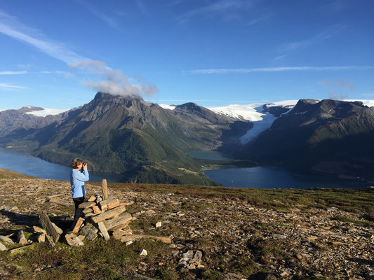
Nachdem das Wetter am Morgen wieder traumhaft schön ist, wollen wir doch noch in den Nordfjorden fahren um die Gletscher und Wasserfälle des Svartisen Gletschers zu bestaunen. Der Wind kommt zwar aus Osten, aber im Kreuz wird das schon gehen. Der Wind nimmt aber, je näher wir dem Fjord kommen, an Stärke zu und hat 15sm vor unserem Ziel schon 30kn, also 7 Bft erreicht – und das gegen an. Die Fallwinde vom Gletscher sind heftig. Nach zwei Stunden beschließen wir umzudrehen und hinaus aufs Meer zu fahren. Je weiter wir das Festland hinter uns lassen, desto schwächer wird der Wind, bis wir schließlich den Motor anwerfen müssen, da es zum Segeln zu wenig Wind hat. Am Abend machen wir ca.20sm vom Festland entfernt auf der Insel Træna fest.
In the morning the weather is again fantastic so we decide to go to the Nordfjorden to see the glaciers and waterfalls from the Svartisen glacier. The wind blows from the east as headwind, but we are sure that it will work. The closer we get to the glacier the stronger the wind blows. There are still 15 nm to go but the wind speed is already 30kn/ 7Bft. The winds from the glacier are quite strong. After two hours sailing we decide to stop sailing into the Fjord and to turn 180 degrees to sail out to the sea. The more distance we get to the mainland, the less wind we have. Finally we even had to motor as the wind drops completely. In the evening we moor in Træna, a remote island 20nm off the coast.
15.09.2016 Insel Hestmona und Bergtour auf den Hestmannen


Nachdem uns der Hestmannen vom Klubben so beeindruckt hat, fahren wir zurück über den Polarkreis nach Ytre Selsøyvågen. Erst geht es mit dem Fahrrad und dann zu Fuß weiter auf den Gipfel. Der Berg ist der Sage nach ein versteinerter Troll, den die aufgehende Sonne überraschte.
For climbing the Hestmannen we have to sail back across the Arctic Circle to Ytre Selsøyvågen. From the harbour we start with the bike and continue per feet to climb the mystic Hestmannen. Based on an old story, the mountain is a Troll which turned to stone when he was caught by the sunlight..
13.09.2016 Aldersundet mit Bergtour auf den Klubben


Von Tonnes gibt es zwei Möglichkeiten: in den Aldersundet nach Süden oder nach Ytre Selsøyvågen in den Nordwesten. Wir entscheiden uns für den Aldersundet, da wir dort einige Bergtouren erwarten. Wir werden nicht enttäuscht: hinter dem Hafen geht es hoch auf den Klubben mit einer herrlichen Aussicht. Im Norden steht der markante Hestmannen – auf den wollen wir in den nächsten Tagen auch noch.
From Tonnes there are two possibilities to continue: either into the Aldersundet to the south or to Ytre Selsøyvågen to the northwest. We decide to sail to Aldersundet, as we expect there some good mountain hikes. Right behind the harbour there is a trail to the Klubben with an excellent view. In the north we see the Hestmannen – this mountain we will hike in the upcoming days.
10.09.2016 Tonnes am Polarkreis


Es ist nicht mehr weit in das Winterlager und wir sind etwas zu früh dran, darum fahren wir heute nur eine kleine Etappe nach Tonnes. Es liegt direkt am Polarkreis. Die Kugel die den Polarkreis markiert sehen wir auf einer kleinen Insel stehen. Wir wandern vom Hafen zu einer Höhle hinauf, die 180m in einen Berg hineinführt – haben wir dort etwa einen Höhlengeist fotografiert.…?
The distance to our storage place for the winter is not that far away, therefore we decided to sail only the short distance to Tonnes. It is situated directly at the polar circle. The bowl which is signing the polar circle we saw on a small island on our way. From the harbour we hike to a cave, which leads 180m into the mountain. Do we photograph a ghost in the cave…?
08.09.2016 Klokkergården/Rødøya mit Bergtour auf den Rødøløva


Weiter geht es Richtung Süden über Ørnes und Halsa zur Insel Rødøya. Die Insel liegt knapp nördlich des Polarkreises. In Ørnes und Halsa müssen wir jeweils schlechtes Wetter abwarten. In den Regenpausen geht aber doch immer eine Wanderung. Auf Rødøya finden wir fast mildes Klima vor. Geschützt durch einen steilen Berg auf der Nordseite gedeihen auf der Südseite viele Nadel- und Laubbäume. In Klokkergården machen wir unser Boot fest und wandern unter Ankündigung der nächsten Schlechtwetterfront für den nächsten Tag noch am späten Abend auf den höchsten Berg –den Rødøyløva.
We continue sailing to the south. After visiting Ørnes and Halsa and waiting for better weather conditions, we finally reach the island of Rødøya. As the island is situated on the polar circle, we are surprised about the mild climate conditions. Protected by a high mountain from the north there are on the south side lots of different needle and leave trees growing. We moor our boat in Klokkergården and continue immediately to climb the highest mountain – Rødøyløva. For the next morning the next rain is expected.
02.09.2016 Støtt mit Nordlicht


Die Zeit der Mitternachtssonne ist vorbei und die Nächte werden wieder dunkel, zumindest von 23:00 bis 02:00. Wir hoffen jetzt das Nordlicht zu sehen. Dazu fahren wir zur Insel Støtt. Die Insel ist relativ flach und bietet freie Sicht in nördliche Richtung. Die Vorhersage für das Nordlicht - Aurora Borealis - ist für diesen Abend sehr gut.
Since a few weeks, there has been no midnight sun any more. During the night it gets dark again, at least from 23:00 to 02:00. We hope to see the northern light during the next days. Therefore we are sailing to the island of Støtt. The island is flat and provides good view in the northern direction. The forecast for the northern light -Aurora Borealis - is promising for this evening.
27.08.2016 Sørfugløy mit Bergtour auf den Hagtinden


Weiter geht es durch die bezaubernde Inselwelt südlich von Bodo. Als nächste Insel besuchen wir Sørfugløy. Die Insel hat einige Sommerhäuser, im Winter ist sie unbewohnt. Eigentlich eine Vogelinsel, aber zu dieser Jahreszeit sind die Jungvögel bereits groß, und die Nester sind verlassen. Sørfugløy besteht aus steilen Felsen, doch den höchsten Gipfel kann man über einen steilen Pfad besteigen. Der Weg ist nicht markiert und manchmal schwer zu erkennen. Die Tour wird nicht so oft gemacht, im Gipfelbuch sind gerade mal 30 Einträge für 2016 verzeichnet. Auf dem Weg dorthin wandern wir durch steile und endlose Wiesen voll mit Blaubeeren und Himbeeren. Wir verbringen einige Tage auf der wunderbaren Insel, bevor wir uns nach Inndyr vor dem nächsten Sturm verkriechen.
We continue sailing to the hundreds of magnificent islands south of Bodø. Our next destination is the island Sørfugløy. People live on the island is only during the summer season, in winter the island is empty. Originally the island is hosting thousands of birds, but during this period of the season the baby birds are grown up and the nest is empty. Sørfugløy is an island with steep mountains; however, experienced hikers can climb the highest mountain of the island. The top isn’t visited that often, the book on top of the mountain shows only 30 visits during 2016. On the waz you walk through steep and endless areas full of blueberries and raspberries. We spend several dazs on the island before we sailed to Inndyr for protection of the next storm.
27.08.2016 Krokholmen


Von Bodø geht es wieder zu zweit weiter über Bliksvær nach Krokholmen, zwei kleine Inseln. Wir erleben hier atemberaubende Sonnenuntergänge.
From Bodø we continue sailing to Krokholmen via Bliksvær, two small islands. We are experiencing on both islands a breathtaking sunset.
21.8.2016 Reine/Lofoten


Die letzten Tage auf den Lofoten verbringen wir in Reine. Isabella und Domi gehen auf den Reinebringen, wo wir sie am Gipfel vom Boot aus fotografieren. Wir verbringen die Tage im Ort und relaxen. Das Wetter ist herrlich sonnig und warm. Morgen geht es dann mit raumem Wind nach Bodø, wo wir die Kinder am Flughafen verabschieden.
The last days on the Lofoten we spend in Reine. Isabella and Domi are climbing the Reinebringen. We stayed on our boat and are taking pictures while they are on the top. The weather is beautiful sunny and warm. Tomorrow we will continue and sail back to Bodø. The kids will fly back to Germany.
18.08.2016 Klettern im Nussfjord


In den Nusfjord wollen wir mit Isabella und Domi auch nochmal. Die Lage ist einmalig, und die Einfahrt ein Erlebnis. Wir sind wie beim ersten Mal wieder das einzige Boot am Gästesteg. Isabella und Domi erkunden am Abend mit dem Dingi die umliegenden Buchten und finden an der Fjordwand gegenüber eine kletterbare Linie, die wir am nächsten Morgen dann auch angehen. Eine schöne Plattenkletterei mit fünf Seillängen im 5. Schwierigkeitsgrad.
We intend to approach with Isabella and Domi again Nusfjord. The location is unique and the approach is an adventure. We are again as in early June this year the only guest boot on the pontoon. Isabella and Domi are exploring with the Dingi the bays around Nusfjord. They discover a possible climb on the rock wall opposite to the entrance of the harbour of Nusfjord village. On the next day we are able to climb it successfully. It has five pitches and we rated the climb with UIAA grade 5.
15.08.2016 Klettern in Henningsvær


Von Svolvær nach Henningsvær sind es nur ein paar Meilen zu segeln. Unsere Gäste Isabella und Domi wollen klettern. Da sind wir hier gerade richtig. Zwei der besten Routen im Gebiet stehen auf dem Programm, und werden nach anfänglichen Schwierigkeiten mit dem Wetter auch durchgeführt. Das Wetter ist in den letzten Wochen nicht so stabil: wenig Wind und etwas mehr Regen. Mal sehen, was der September und der Herbst bringen….
From Svolvær to Henningsvær it is only a short distance. It is the right location for our guests Isabella and Domi to go rock climbing again. Two of the best climbs of the area are on our agenda. Currently the weather isn‘t that stabil, but we succeeded. It seems the weather has changed during the past weeks: less wind and more rain. Let us see what the September will bring.
12.8.2016 Svolvær mit Klettern auf die Svolværgeitha


Svolvær ist die Hauptstadt der Lofoten und die Svolværgeita ist ihr Wahrzeichen. Da wollen wir klettern und hoch. Wir sind gleich zweimal auf den Gipfel geklettert, einmal vom Norden und einmal vom Süden. Am zweiten Tag sind wir nach der Besteigung noch weiter auf die Fløya, wo wir am Abstieg an der Djevelporten vorbei kommen.
Svolvær is the capital of the Lofoten and the most significant landmark is the Svolværgeita. That’s where we want to climb to the top. We reached the top two times: from the north and the next day from the south. The second day we continued to the mountain Fløya, where we pass the famous Djevelporten.
11.08.2016 Digermulen mit Bergtour auf den Keiservarden


Gegenüber dem Ausgang des Trollfjords liegt Digermulen. Der Ort hat zwei Merkmale: zum einen ist es dort bedingt durch die geschützte Südlage etwa im Schnitt zwei Grad wärmer als in der Umgebung und zum anderen den Keiservarden. Kaiser Wilhelm II war zweimal auf dem Gipfel und hat von dort die herrliche Aussicht genossen. Der Keiservarden trägt seitdem diesen Namen.
From the exit of the Trollfjord just across the Raftsund there lays Digermulen.The village has two characteristics: first of all it is in average two degrees warmer than in the surrounding area because of the sheltered place and secondly because of the mountain Keiservarden. Kaiser Wilhelm II visited two times the mountain from where you have a fantastic view.
10.08.2016 Trollfjord mit Bergtour zur Trollhytta


Um in den Trollfjord von Norden zu kommen, muss man durch den Raftsund. Die Strömung kann hier mit 6 Knoten sehr stark werden. Aber mit dem richtigen Zeitfenster geht Strömung und Wind nach Süden und transportieren uns gemütlich zum Eingang des Trollfjords. Der Fjord ist eines der Highlights einer Norwegenreise. Wir sind dort ganz alleine. Am Ende des Fjords hat es einen Steg an dem man festmachen darf und auch über Nacht stehen bleiben kann. Dass wir von dort auch die zwei Stunden Fussmarsch auf die Trollfjordhütte gehen, macht den Tag komplett.
If you want to get from the north to the Trollfjord, you have to pass the Raftsund. The current in the Raftsund can be with 6 knotes very strong. With the right timing we were pushed by the current and the wind gently to the entrance of the Trollfjord. The fjord is considered one of the main highlights of a journey through Norway. We are the only visitors. At the end of the fjord there is a pontoon where we fixed the boot and stayed overnight. A two hours hike from there to the Trollfjordhut made it a perfect day.
07.08.2016 Stø und Wanderung auf der Dronningruta - Bø auf den Vesterålen


In Harstad steigen Isabella und Dominik zu und sind für die nächsten drei Wochen unsere Gäste. Wir wollen wieder hinaus ins Nordmeer und segeln über Grøtavær nach Stø. Dort unternehmen wir an der Küste entlang die Wanderung Dronningruta – Königinroute, die uns auf über 500m über das Meer führt. Den Namen hat die Route der norwegischen Königin Sonja zu verdanken, die seit vielen Jahren hier auf den Vesterålen wandert. Die einsamen Etappen im Nordmeer rund um die Vesterålen Enden in Bø, bevor wir morgen nach Stokmarknes und weiter in Lofoten fahren
Isabella and Dominik join us in Harstad for the next three weeks. We are heading again towards the Nordmeer. The next legs are passing Grøtavær towards Stø. There we hike along the coastline the so called Donningruta – the route of the Queen, which leads as more than 500m above sealevel. The name was created due to the fact that the Norwegian queen Sonja has been hiking since years on the Vesterålen. And this hike was her favourite hike. The remote legs around the Vesterålen end in Bø, before we will continue tomorrow the Stokmarknes and continue back to the Lofoten.
02.08.2016 Skrolsvik/Senja


Da das Wetter sich inzwischen beruhigt hat können wir entlang der Küste Senjas nach Süden weitersegeln. Die Wellen sind vom vergangen Sturm anfangs noch sehr hoch. Unser nächster Zwischenstopp ist an der Südwestecke von Senja in Skrolsvik. Am Abend kommen plötzlich 16 Segelboote in den Hafen: wir sind mitten in der Regatta „Rund um Senja“…
As the weather has calmed down, we can continue along the Senja coastline towards Harstad. The waves are during the start of this leg still quite big, but the wind allows good sailing. We stop in Skrolsvik in the southwest of Senja. In the evening suddenly 16 Sailing vessels are entering the harbour: they are sailing a race and have a stopover for the next leg round Senja.
28.07.2016 Senjahoppen


Jetzt wird das Wetter richtig schlecht, mit Nordost Wind, bis 10Bft Wind und viel Regen. An ein Weiterfahren ist nicht zu denken. Da der Hafen sehr geschützt ist kommen auch viele Fischerboote nach Senjahopen. Einige Wanderungen gehen aber in diesen Tagen dennoch.
Now the weather gets really bad, a strong northeast wind with up to 10Bft and lots of rain. We did not even think to continue our trip to Harstad in this weather conditions. As the harbour is known to be very save, now also many fishermen are entering Senjahopen for protection.
Kommentar schreiben
Gabi und Norbert (Samstag, 20 August 2016 15:35)
Hallo Ihr Lieben, das wurde aber auch Zeit mit den neuen Bildern. Wir dachten schon die Batterien sind leer, doch dafür sind die Aufnahmen umso schöner - danke dafür! Wir wünschen Euch natürlich schönes und beständiges Wetter, damit Ihr noch all die geplanten Unternehmungen machen könnt, die Ihr Euch vorgenommen habt. Alles Gute weiterhin von Gabi und Norbert
Gabi und Norbert (Donnerstag, 29 September 2016 14:44)
Servus Ihr zwei, die Uhr läuft ... Man kann es nicht glauben, doch das halbe Jahr ist um. Vielen Dank für die wunderschönen Fotos und den kleinen Filmbeitrag. Es hat wirklich sehr viel Spaß und Freude gemacht Euch zu begleiten und zu "verfolgen" - wenn auch nur aus der Ferne - mitzusegeln und zu genießen. Vielen Dank dafür - kommt gut wieder nach Hause - Grüßle Gabi und Norbert
Georgetta Lipsey (Donnerstag, 02 Februar 2017 07:54)
I couldn't refrain from commenting. Exceptionally well written!
Retta Wierenga (Dienstag, 07 Februar 2017 01:53)
I've been browsing online more than 4 hours today, yet I never found any interesting article like yours. It is pretty worth enough for me. In my opinion, if all website owners and bloggers made good content as you did, the net will be a lot more useful than ever before.